Norikura

It was almost midnight by the time I reached the base of Norikura after Yakedake, and set up the tent under the roofed terrace of a restaurant, so we slept well if only briefly. At 3.54 precisely, the dawn-viewing bus pulled in to pick up passengers and whisk them to the top of Japan’s highest road, Norikura, at 2800m, to watch dawn break. But I had other plans.

I stashed the tent, assembled the bicycle, and rode up the 10km in the half-light before dawn, just as the birds were waking. This was much more enjoyable than the agony of the hill-climb race in August. Only buses and taxis are now allowed to use this road, so it was safe for Hana to run alongside. The air was still cool and at this altitude, the surrounding green was that of spring.

At the trailhead, I swapped cycling shoes for running shoes, and walked up alongside the last of the snow toward the summit, startling a ptarmigan. Fortunately the dog has been trained not to chase birds (involving walking through flocks of strutting pigeons in the local park and picking her up by the scruff of the neck when she reacts).

At 6 am, the summit was busy with hikers who had come up from the nearby hut. An elderly couple from Nagoya insisted on feeding me a leisurely breakfast before I made my way back to the bike, stuffed the dog in her Montbell (yes, really!) rucksack, and gave Hana the descent of her life. I was back in time for work soon after 9. What a great way to start the day.

Yakedake

It takes some faith in technology. From the comfort of home:
1. Choose the quickest route from the paper hiking map.
2. In Kashmir software, find and plot the route.
3. Copy the coordinates (Tokyo datum) to the Sony car-navi (NV-U2).
Then plug in the car-navi and drive off in the dark to an entirely unknown mountain.

On Tuesday night, it amazed me yet again as I drove up the narrow hairpin bends toward the base of Yakedake, near Kamikochi. Precisely as the car hits the checkered flag on Sony’s screen, a small carpark appears in the headlights, opposite a hand-painted wooden sign marked 焼岳登山口. Those words 登山口. Finding the start of a hike can sometimes be the hardest part.

Under the clearest of starry skies after the rainstorms of late, we moved silently up the hulk of Yakedake. The path was a soft bed of cut sasa grass almost until the final rocky peak of Kitagamine, whereupon a roar like a jet-engine grew louder and louder in the still air. I could see and smell the sulphurous steam billowing up over the lip of the crater and blotting out the stars, but the source of the noise was a powerful steam vent by the side of the path. I turned around and Hana was nowhere to be seen.

I retraced my steps down past the vent, and the small torch eventually caught two luminous blue dots far down the slope, certainly not on any path. Poor thing, she must have been terrified by the noise and stench. Yet last weekend, as I had sat on the deck outside and watched the monstrous lightning storm that cut the power of the whole area, toasted a neighbour’s PC and made a telephone set jump across the room, the dog had fallen asleep in my arms.

Jonendake

The GPS that I had lost near Hijiridake a week ago has been returned to me! The track log shows that I lost it on the climb up Hijiridake, and whoever found it then carried it with them up to the top, then descended back to Hijiridaira hut.

After I called the tourist association office whose number is listed for several of the huts in this area, they confirmed that the GPS had been handed in to the hut, and one of the hut staff duly carried it down the mountain a couple of days later, and sent it by takkyubin to me. What a wonderful country!

Today, I had intended to deal with the unfinished business of Kitadake and Ainodake, but with the forecast for thunderstorms, I headed off for an early piston up Jonen. Perfect blue skies and an iPod made for a fast, thoroughly enjoyable run. I returned home just in time before a terrific lightning storm shattered the sky and cut the power. I watched the lightning striking for a good hour around Kitadake – lucky I was not on that exposed ridge.

Mt. Fuji revenge

With the impetuosity of youth, when the race gun went off, I ran far harder than was sensible, and consequently suffered terribly for the next two hours to the fifth station, where the gods had kindly arranged a typhoon and the remainder of the race to the summit was called off.

I vowed never to do the race again. But that was some 15 years ago, and time dulls the pain and dims the memory. And so I found myself at the start line in Fuji-Yoshida once again, staring up at the massive bulk of Mt. Fuji, with the goal 21 km distant and almost 3000 meters higher.

With the aim merely being to finish within the cut-off of 4.5 hours, this time the “race” was actually enjoyable. Once the asphalt had finished after 11km and the climbing started, the last few months of being in the hills paid off and I could settle into a rhythm, checking the altimeter every 15 minutes and calculating estimated arrival time. I felt keenly aware of a responsibility to stay alive (I was not quite married last time) and so kept a steady, comfortable pace. Unfortunately, a 59-year-old man was not so lucky, becoming the first fatality in the 61 years that the race has been held.

I was surprised to see that, beyond the fifth station, the route was the regular hiking trail, which was packed with everyone from elementary schoolkids to octagenarians. More surprisingly, I saw no tension between the hikers and 3000+ runners, neither when hikers held up runners on narrow sections, nor when runners kicked up clouds of dust on the scree descent. I felt sorry for the unsuspecting hikers who happened to have picked the wrong day.

The best part about finishing is that I never, never have to do it again. Oh, except to take the dog up.

Shiomidake

After two long days, I could not face a third 18-hour maptime day to Kitadake and Hirogawara, and I made silent excuses that perhaps the dog would struggle with the distance and the heat. I set off at 2:30 am under a shockingly bright moon, reached the summit of Shiomidake in time to enjoy the dawn roll out across the clouds beneath, then descended lazily to civilization. Ainodake and Kitadake will be enjoyable later in the year on a fresh pair of legs.

Akaishi + Warusawa

Refreshed after sleeping and refueling, we made good time up over Akaishi and on across the dramatic, rugged ridgeline, now moving toward the midsection of the route. This was where other approaches join from the east for hikers wishing to make just a one-night trip to Akaishidake and Warusawa. The relatively convenient access, though still 6 or 7 hours from Tokyo just to the trailhead, had brought a couple of hundred, mostly elderly hikers to admire the wildflowers on Warusawa. But no sooner than I had gone 5 minutes beyond the Warusawa junction on the ridge and I was on my own again, and I saw no one else for the next 5 hours.

As I emerged into the clearing of the Takayama emergency hut, I noticed the owner standing in the doorway, arms folded, staring at me. I slipped the lead onto Hana, anticipating a tongue-lashing. “So you’re the person who set off from Tekari yesterday? I’ve never heard of that before, and I’ve been here since this hut was built 30 years ago.” He had been informed by hut radio, presumably from Tekari or Hijiridaira.

But he was wrong. The TransAlps trail-running race passes this way once every two years, averaging  60 km a day in a 7-day, 420km coast-to-coast unsupported run across the Northern, Central and Southern Alps. The runners, and the number is limited to just 10, are not even allowed to stay in the huts or buy food there. Entry costs just 1,000 yen, but there is no support whatsoever, indeed, support of any kind is prohibited. In 2006, just two finished. The winner and Japan’s leading trail runner, Takahashi, died of a heart attack the following year in the 132 km TokyoTrailRun. The other was Mase Chigaya, in her 40s, housewife, and mother of two.

As the old man poured me a cup of oolong tea, he explained that Tokai Pulp owns most of the Southern Alps, including this hut. The hut is only open for a couple of months, and he used to carry in all his food, but he admitted, “Now the company drops me and the supplies in by helicopter, just an hour from Matsumoto. Once you’ve experienced that luxury, you’ll never hike it again.” Even at age 70, he still carries a chainsaw and tools to fell trees and clear the trail. I offered him some muesli, but in reply he merely opened his mouth to reveal no teeth. We sat on the bench and chatted in the sunlight filtering through the trees. He seemed perfectly content.

Encouraged by his warmth, I pushed on for another 3 hours to Sanpuku. Along one of the most beautiful routes, dipping through forest paths before breaking out onto exposed ridges, with landslides carving the mountainsides, I came across only one other hiker. He was sitting peacefully on the edge of a collapsing ridge, a drop of a thousand foot at his feet, staring into the distance and waiting for the mist to clear. A serious Himalayan mountaineer in his youth, he was now in his sixties and enjoying the easy hikes of Japan. His mission was rockie-han. “You don’t know that word?” he asked. “Location hunting.” He carried a large SLR and phalanx of lenses, but this was merely a prelude. When the production chief back in the studio had seen the photos that he would take and made his choice, this elderly man would return with a massive plate camera weighing 10kg.

Tekaridake + Hijiridake

The Southern Alps may not have the name value of the Northern Alps simply because of their inaccessibility. After a three-hour local train and an eye-watering Yen 17,000 taxi ride later, the driver dropped me at the trail head. He was clearly nervous about driving deep into the mountains at night, and before he left, handed me a couple of biscuits.

Perhaps I should have placed them under my tongue as payment for the ferryman across the Styx, for that was how I felt, embarking on a journey into another world on the roof of the Alps where I would remain for the next three days.

But it was a relief to be climbing up through the forest, gaining altitude and leaving the heat of the valley below. The rainy season had officially ended with the last downpour earlier in the day, and temperatures would soon soar into the 30s. The soft pine-needle path was still warm and damp, and the full moon cast ghostly, moving shadows that played among the tree roots.

I reached the Tekari hut campsite at 1 am but there were no other campers to disturb. The campsite was a small but cosy hollow next to the hut, and had been carefully leveled and cleaned of stones by the intelligent, lively couple who ran the hut. They came out in the morning to warn me to stock up on water at the spring a few minutes below, since there was no other water for the next five and a half hours to Chaosudake.

But I flunked this first test. After 30 minutes of descending, a sense of panic began to rise. I had clearly missed the water, and had no more than a cupful remaining in the Platypus. The morning sun glistened tantalizingly on the dew-covered grasses and ferns lining the path. I tried to scoop up the beads of water with the plasticized map, but it was clearly not enough to slake our thirst.

I had no extra clothing, other than Goretex, down jacket and a spare pair of underpants. There was no choice. I took out the underpants and brushed them repeatedly through the grasses, then wrung out the dew into a bowl. Soon Hannah and I had drunk our fill, leaving only the soapy aftertaste of Fabreeze. At least they were my own underpants…

It was a relief to arrive at Chaosu and find the hut had just opened for the summer season. The staff had arrived that morning, and vivid red tomatoes were bobbing in an ice-cold bucket of running snowmelt. I was the first visitor, and a girl brought me a cup of tea and cakes, all part of the most friendly welcome I have ever received at a hut.

We set off for Hijiridaira hut. I would decide there whether to continue or camp. Another few hours later in the rising heat and both the dog and I were wilting upon arrival. Some snacks for the dog and salty noodles for me revived spirits and we set off again, now committed to reaching the Hyakkenbora hut for an 18-hour maptime day.

After climbing Hijiridake and descending the other side, I realised my GPS had dropped out of the rucksack sidepocket. So that must have been what the shouting had been about near the hut! But going back now would add another three hours and make today’s plan impossible. I hope that Japan’s famed honesty and safety will result in the GPS finding its way back to me.

By the time we reached Hyakkenbora, I was shattered. This was the price of insufficient liquid earlier. Upon checking in at the hut campsite and being asked my destination for tomorrow, I answered “the next world” for that would have suited me. I crawled into my tent and in spite of the rough stony ground, slept for 10 hours straight.

Utsugi + Kisokomagadake – Traumatised

After 3 hours’ sleep, it took a while to get going on Utsugi. At the top, there was a like-minded hiker in his fifties, in shorts and half-sleeve shirt, who perked up when I arrived. He had driven up from Tokyo the previous night, got an early start, and was driving back to Tokyo in the afternoon. After a brief chat, I started to run the descent as usual, but soon became aware of laboured breathing behind me, and was startled to find the man running a short way behind. “I just love your dog,” was his explanation.

The same was not the case on the next mountain, Kisokomagadake. I had intended to take the long ridge route from Utsugi, but the logistics of getting back to the car prevailed. So with reluctance, I joined the crowds of day-trippers for one of Japan’s fastest gondola rides up to 2600 meters, listening to the ironic commentary about preserving the beautiful natural environment.

Yes, women in high-heeled shoes and short skirts were tip-toeing daintily through the final remnants of snow. Children’s screams of “Ya-ho” echoed back from the impassive, grey-faced mountain walls. And the crowds. Oh, what had the fine weather and convenience of the cablecar brought? On the track of just a few hundred meters up to the ridge was a solid stream of assorted hikers, inching their way up or down, each one within whispering distance of the next.

As I started up, suddenly an almighty voice boomed down from the top of the line. “DOGS ARE NOT ALLOWED. GO DOWN. NOW!” He was practically screaming. A hundred heads turned around in unison to stare. The background chattering ceased.

In an instant, I was carried back to my schooldays and the awful bullying, dormant feelings of dreadful revenge resurfacing after all these years.

No one said a word as I walked up, not until I reached the owner of that vitriolic voice, a stocky, aggressive man in his sixties. He was livid. “Get back down!” he shouted again, his face a menacing puce-red. “You’ll scare away the mountain animals.” He had to be kidding, but he was not. I swept my arm around in the direction of a mountainside filled with hikers, “That’s why there are no wild animals here,” and carried on.

But the whole day had been ruined and my nerves shattered. Regardless of the legality, and the whole hypocrisy, he firmly believed that dogs are not allowed in the mountains. If I had not taken the dog, the ugly scene would not have happened. It has taken me a couple of days to regain my nerves.

I generally try to avoid trouble, so I shall have to choose my remaining routes and times more carefully.

Ontake

 
At 9 pm on a Friday evening, there was already a handful of hikers settling down in their cars for an early morning start on Ontake. I envied them, but I had to get back before my brother-in-law came to stay the next evening.As I set off up the path, the calm night air was periodically ripped apart by crackling lightning. I counted the seconds for the thunder rolls to reach, aware of the metal crampons strapped to the outside of my pack. They were surely an inviting target for the gods to point a finger at,
 
 
but mercifully the storm was not getting any closer. Besides, a god with a sense of justice would strike the vending machine that sits at the top of this sacred mountain.

After the calm of the start, the buffeting winds and thick wet mist at the summit were a shock. I could see no further than a few meters, and in the rush to descend, I took a wrong turn through the maze of huts below the top, and was only saved by the GPS clearly showing that I was heading in precisely the opposite direction from which I had ascended.


Chokai + Gassan – The Taunt of Hakusan


We both suffered this morning. Chokai on the map looked a breeze, but the maths did not tally. Asahidake was approximately 1300 meters of altitude gain, one-way distance of 8.2 km, map climb time of 6 hours. Chokai was a slightly smaller gain, the same distance, but a climb time of 4 hours, and it felt a hard slog.  Perhaps we were simply tired.

The Shinzan peak was a heap of murderously sharp, large rocks, many of which had been defaced with name carvings. Mind-boggling to imagine guys (presumably) preparing mallet and chisel for such premeditated action.

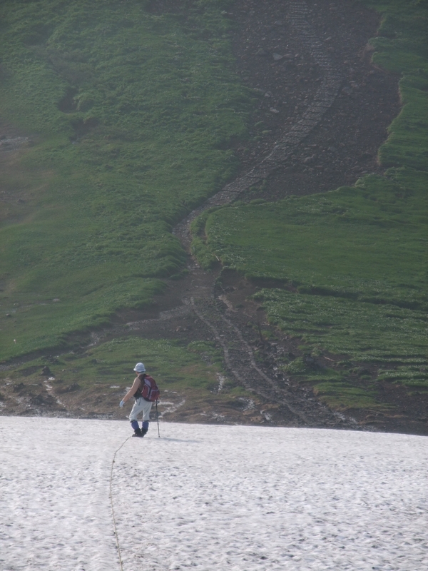
The conventional way to descend a snowfield …

Keisuke showing the quicker way …

At the base of Gassan there was a sentrybox, the stuff of nightmares, manned by a crusty old man who scornfully looked at my running shoes, “You have got proper mountain boots, haven’t you?” Yes, I had. Still in the car. “You can’t get up without crampons. Impossible!”

He was trouble, so I packed Hana into her carrycase before taking her out of the car, covered the case with my wind jacket, and then dashed past the guard while he was hectoring another would-be climber. I kept her in the case for the short chair-lift ride, but at 2 pm, we were the only ones going up, passing a steady stream of satisfied hikers on the descending chairs. As we neared the top, the first spots of ominously heavy rain fell. Within 5 minutes of hiking, the heavens opened. Keisuke, with no particular agenda, wisely returned to the hut. The die-hard skiers rapidly cleared off the slope. All hikers were on their way down. Was I mad? And then thunder reverberated around the hill.

I stopped. This was nuts. Time to turn around. But after backtracking 50 meters, the ghost of Hakusan came back to haunt me. I had abandoned that one because of rain, and now faced a long trip back there sometime. Gassan was even further from Tokyo. Hana looked dismayed as I started back up the slope, my shoes now filled with rain and the path a running stream. Once you’re this wet, it no longer matters. A sweet-looking lady muttered “Kawaii so” as she passed. Yes, that’s how I felt, but she was looking at the dog. Another hiker suggested I be careful of the lightning. I replied that I hoped the gods would be kind. Once the decision was made, the madness of it made the climb enjoyable. And of course, almost no one was wearing crampons.

I raced through the entrance to the shrine at the top, past the hut and up the final few steps to the summit when a loud voice summoned me, “Come here!” I was surprised to see a priest, who in the politest of ways, informed me that I would have to pay 500 yen if I wished to go up those steps, and that dogs were not allowed within the precinct, for this was a holy place.

Normally, I might have argued back, but the Power of the Church was indeed mighty. “Stay!” kept the dog at the entrance, the priest blessed me for 500 yen with a wave of his white wand, and after paying my respects at the shrine, I asked the priest to keep the gods from striking me down with lightning on the descent. It was money well spent.